Cycling Southwest France - Biking the Dordogne
Description and planning of the trip
This is a cycling trip that my biking partner, Len Kleinrock, and I took in September 2005. As can be seen from other descriptions on this web site, Len and I have been taking bike trips in connection with meetings of a program which takes us annually to some European city. (The program is TTI Vanguard, www.ttivanguard.com, a series of technology seminars for business and government executives. Len chairs the program and I am a member of the Advisory Board.)
The way we take bike trips is to make them do-it-yourself events. We choose our own itinerary, plot a route, make reservations to stay in hotels along the way, and carry our own baggage in panniers on rented bikes. We enjoy the feeling of independence and the pride of accomplishment in doing things our own way without the support of a packaged tour.
Apparently our approach is rather unusual. I can't recall on any of our trips encountering other cyclists doing their trips this way. The great majority of cyclists are on some kind of pre-arranged tour, almost always one that takes their baggage from hotel to hotel. That seems too easy, particularly when there is a sag wagon to take challenged cyclists up hills. On the other hand, a smaller number of cyclists are loaded down with panniers stuffed with tents and camping gear. I admire their initiative, but on cold rainy days I'm always glad that I have a hotel and hot shower waiting at the end of my journey.
Choosing an Itinerary
Our meeting for 2005 was in September in Geneva. We looked for some bike trip that was within an easy train ride from Geneva. Our criteria were as follows:
1. We wanted a route that was approximately 230 miles long, good for a seven-day trip, starting in a city with a major train station and ending in another city with a major train station.
2. The route should not be a loop. We like to feel that we're getting someplace.
3. There should be towns with hotels about every 30 miles.
4. The route should contain interesting tourist attractions.
5. The route should not traverse mountains and preferably should not have a lot of steep hills.
6. The roads along the route should be relatively safe for cycling.
These are surprisingly hard criteria to satisfy, particularly the bits about hotels and interesting stuff. Some of the criteria are even almost mutually exclusive. For example, though our meeting was to be in Switzerland, it seems impossible to find a 230-mile route through interesting places in that country without crossing mountains.
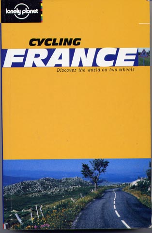
France in our experience is a bike-friendly country near Switzerland, so we concentrated on routes there. Len and I had previously cycled through Brittany and Normandy. We both had toured the Loire Valley several times, so we ruled that out, and Provence is interesting, but hilly. Finally we settled on southwest France -- along the Dordogne River, its tributaries, and the Perigord region. In this choice we were helped by web searches for packaged cycle tours. Even though we choose not to use these tours, their operators generally know where the good cycling is. I'd also like to recommend the Trento Bike Pages (www.trentobike.org) as an excellent guide to European cycling on the web. Another excellent guide is the Lonely Planet book Cycling France.
A Good Guide to Cycle Routes in France
The Cycling France book describes two tours in southwest France. One tour, the "Bordeaux Wine Explorer" is a tour concentrating on vineyards near Bordeaux. The other tour, "Caves and Cuisine", goes eastward through hills dotted with prehistoric caves. Neither tour was exactly what we wanted, but we were able to incorporate four days of the latter tour into our final itinerary, as well as a portion of one day of the former tour.
We were constrained by the necessity of starting and ending near major train stations. From the beginning of our deliberations we decided to start near Bordeaux and work our way eastward. However, we had no desire to fight the traffic in biking out of Bordeaux, so we decided to start in St-Emilion, a small, charming town nearby. The eastward direction was consistent with the prevailing winds in the Bordeaux area (listed in the Cycling France book). In our trip we did, in fact, have the wind at our back except on two occasions when our route took us westward. Other than at those times, we felt no wind -- a sure sign that we had a tail wind.
Here, then, was the problem: starting in St.-Emilion find towns with hotels every 30-40 miles for seven days, go through as many Michelin-recommended tourist attractions as possible, and end in a city with a major railway station.
Actually, there isn't any real answer to that problem. In the end we had to choose an itinerary that had some longer and shorter days, as well as a "loop" recommended by Cycling France. Moreover, the seventh day was merely a long trek without particular interest to a city, Cahors, where we could get a train.
Here are the towns and distances in our itinerary:
Day 1 -- St.-Emilion to Bergerac, 41 miles
Day 2 -- Bergerac to Les Eyzies, 39 miles
Day 3 -- Les Eyzies to Montignac*, 19 miles
Day 4 -- Montignac to Sarlat*, 28 miles
Day 5 -- Sarlat to Vitrac*, 26 miles
Day 6 -- Vitrac to Rocamadour*, 34 miles
Day 7 -- Rocamadour to Cahors, 39 miles
*described in Cycling France
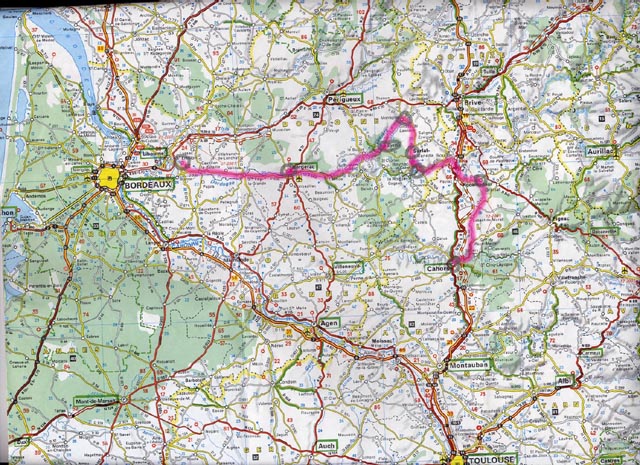
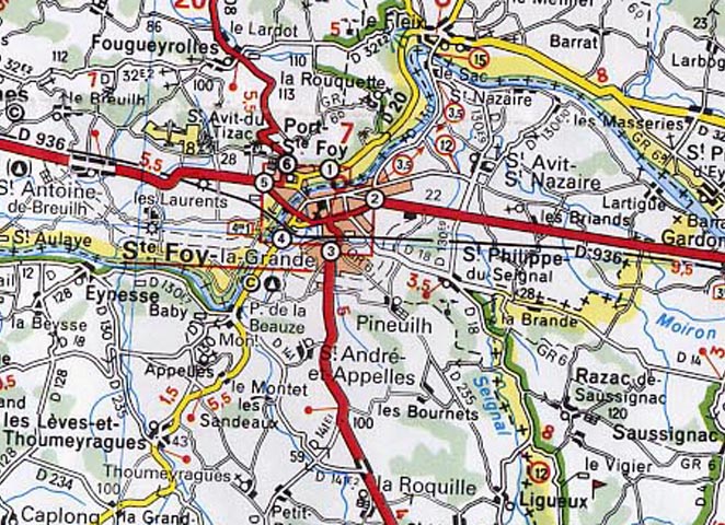
Our Itinerary Shown on a Michelin Map
We made hotel reservations in each of these towns. This is a popular tourist area, and there aren't many hotels, so I believe that reservations are really necessary.
One of the really nice things about cycling in France is the easy availability of rental bikes. There are even several bike rental agencies that will, for a fee, deliver bikes to one city and pick them up at another. This service is a bit pricey, but the savings in time and bother are enormous. In our previous bike trip in France we had dealt with one of these agencies and had received good service, so we used them again. I'm glad to recommend Florent Laroux at www.customized-tours.com.
Choosing a Route
I often lament the fact that there aren't maps specialized to cyclists. In a car you simply want to get from one point to another, preferably by the fastest route. When cycling, you'd like a lot more information -- how safe is the road for cycling, how hilly is it, and how interesting is the scenery? I have yet to find a map from which you can determine these questions. The issue of safety is a complex one in itself, because it is a combination of factors -- how wide is the road, how much traffic is there, and how fast is the traffic? Obviously the worst thing is to have a narrow road with a lot of fast traffic, while in the absence of traffic even a narrow road can be most pleasant and safe.
Certainly, the general rule is to take secondary roads. In France, these are the "D" and lesser roads. However, there are many exceptions in both directions. Some small roads can have relatively heavy traffic, while some major highways can have accompanying bike lanes. Unfortunately, you can't tell from a map. One criterion that I use is to see if a secondary road is near a major highway going to the same place. I then imagine that cars would choose the highway and leave the secondary road empty. This isn't foolproof, however.
The question of hills is a little easier to answer, but not with the accuracy I'd like. The crudest indication is on the Michelin maps, which use a "<" and "<<" to indicate "steep" and "very steep." Also, Michelin maps have high elevations noted in various places, so you can gauge the general rise in a particular area.
I have the Fugawi map software with elevation data for Europe on my home computer. However, this was practically useless for two reasons. First, Fugawi doesn't have the secondary roads in France, and second, the elevation data seems to be averaged over relatively large areas. I checked an elevation profile of our previous trip in France, and the profile did not correspond to the actual elevations measured by my GPS during the trip. (On the other hand, I should say that for England the Fugawi software has all the roads and the elevation data is quite good.)
Recently, GoogleEarth has been offered free through the Google homepage. This is a great boon to bikers interested in looking at possible routes.
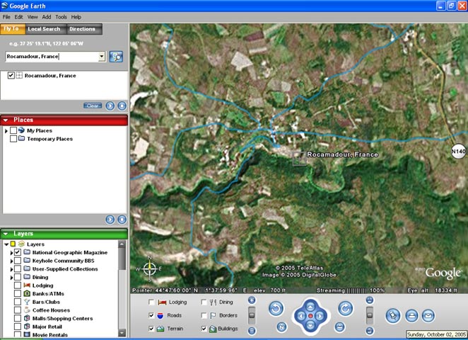
GoogleEarth View of Rocamadour, France
This picture shows the GoogleEarth view of one of our destinations, Rocamdour. Notice that there is elevation data (700 feet), so that you can run the cursor along a road and check elevation. However, Rocamdour is on a cliff, and you won't find the cliff in the elevation data. Apparently, the elevation is linearly extrapolated from a grid of samples, so it is unreliable as to steepness of hills. Furthermore, as in this picture (at a height of about 18,000 feet), the available resolution is rather coarse in many locations. Nonetheless, GoogleEarth is a lot of fun and occasionally useful.
The Cycling France book has elevation profiles for the rides it describes. Here's the data for one of our days.
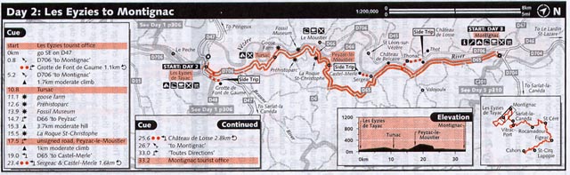
Cycling France Description of Route from Les Eyzies to Montignac (Elevation profile in lower right).
We have found that the elevation profiles in Cycling France are good general guides to the locations of hills and their heights, but not to their steepness. It often looks from the profile as if there is a steady slope up a hill, while in reality the steepness varies. We also were disappointed several times in the accuracy of the route descriptions ("moderate climb", "steep climb", "very steep climb").
As much as I would have liked to have avoided hills, there really wasn't a lot of choice in this region. There are a fair number of moderate hills, and in the end we laid out a route without much consideration of hills that would be encountered. In charting our route we used three sources: Cycling France for the days where we followed its route, and Michelin Regional Maps 525 and 526 as well as the Garmin MapSource software for the other days.
Here's a snippet from Michelin Map 525 (Aquitaine) to give you an idea of the available scale. I recommend these maps as displaying all the roads and being highly visual.
Example of Section of Michelin Regional Map 525
We plotted the route using the Garmin MapSource software (which does have all the roads in France, but no elevations), so that we could transfer the routes to our GPSs. Here's an overview of the route as laid out in MapSource.
The Route from St-Emilion to Cahors as seen in Garmin MapSource
Len and I, being techies, are addicted to using a GPS on our bikes. For complicated routes like this it is an invaluable aid to navigation. Just follow the dots, and don't worry about wrong turns, which will become evident very quickly. Besides, a GPS is a lot of fun.
Packing
After seven similar biking trips in Europe I like to think that I have packing down to a science. Every pound and cubic inch has to be carried on our bikes up every hill. On the other hand, I have to be prepared for all kinds of weather and emergencies, and have to have clothes appropriate for cycling, evenings, and a business meeting. Still, it is surprising how little you can get away with, especially if you plan on a wash or two.
We have settled on taking our own panniers, handlebar bags, and helmets with us to use on rental bikes. Although all rental places offer panniers, you can never be sure how much they hold. By taking your own you know exactly what you can carry. My panniers hold 2400 cubic inches, and I carry my baggage in a duffel bag that also holds the same volume. The duffel bag folds up and goes in one of the panniers when I bike. Len carries his baggage directly in his panniers. Mine aren't quite as convenient to use on airplanes, so I carry the empty panniers in a shopping bag when I travel. The handlebar bag serves as a carryall while traveling to hold valuables, camera, GPS, books, and travel documents.
Here I am, leaving home with all my stuff. The panniers are in the yellow plastic shopping bag. On my other shoulder are the handlebar bag and a black duffel bag containing clothes, toiletries, and biking outfits. That's everything.
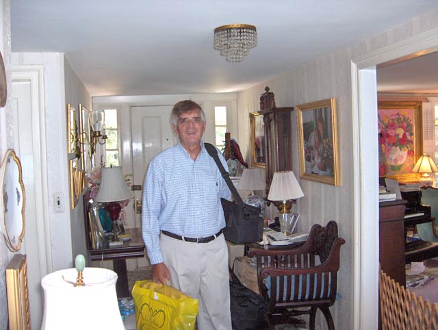
Leaving Home with my Baggage
I try never to check baggage on airplanes. Too much can go wrong, and you lose all your flexibility to change flights. In past trips I've had to check the baggage shown in this picture because of the presence of a bike tool that wouldn't get through security at the airport. So this year I decided not to take the bike tool, which I've never needed on previous trips. So I didn't have to check any bags. Of course, as it turned out, I needed the bike tool! Next time I'll look to buy a different bike tool that might get through security.
Statistics for the Trip
Days -- 7
Total distance -- 227 miles
Average moving speed -- 9.1 miles per hour
Maximum speed -- 32.1 miles per hour
Peak elevation reached -- 1467 feet
Total elevation gained during trip -- 12,744 feet
Highlights of the trip
In thinking back through the trip, these are the things I liked the best:
- Biking along lonely, tree-covered roads overlooking the river on beautiful days.
- Crossing over the many bridges offering panoramic views of the river and towns.
- The medieval town in Sarlat
- Seeing the famous prehistoric cave paintings in Lascoux
- The town and cave-littered environs of Les Eyzies
- The spectacular setting of Rocamadour
- The charming small town of St-Emilion
- The old town in Bergerac
- The pretty river setting of Montignac
Not so good parts of the trip
There were a few parts of the trip that I could have done without. These include:
- The last 14 miles into Bergerac were very boring, along a straight main road with a lot of traffic and no memorable scenery whatsoever.
- The last day, from Rocamadour to Cahors, intended principally just to get to a railroad station, was largely devoid of charm.
- Cahors itself was disappointing, except for the ancient and famous bridge.
Proceed to Day 1 of the Dordogne Trip
Back to Bob Lucky's Main Biking Page