Henry Hudson Trail and Bike Path

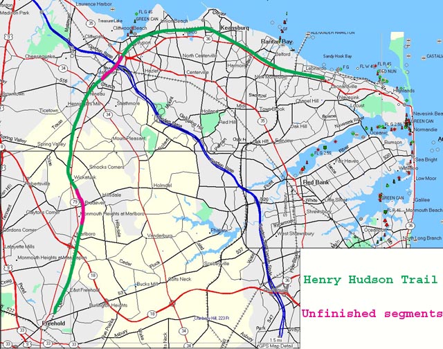
Henry Hudson Bike Path (in green; unfinished portions in red)
The Henry Hudson trail is a bike/pedestrian path paved in asphalt over a disused railway line that extends from Freehold north to Keyport and then east to Atlantic Highlands. The total length is about 22 miles. However, this trail is a work in progress, and as of October 2005 there are two unfinished sections, breaking the trail into three separate sections.
The two breaks in the path are each about 2 miles in length, and while it is possible to bike on highways between the segments, there seems to be little incentive to do so. For example, between the Freehold segment (lower left) and the Matawan segment (upper left), you can bike approximately 2 miles northwards on Route 79 to rejoin the trail. However, this is a busy 2-lane highway. There is a marked shoulder wide enough for bikes on this highway, but biking there would be unpleasant at best. Between the Matawn segment and the Atlantic segment you can bike on Route 516, but again awkward and busy. Unfortunately, as of this writing in the fall of 2005, there appears to be no work ongoing to finish these connecting segments. Apparently there is some political debate in the New Jersey legislature about bringing back the Monouth-Ocean-Middlesex railway, over which the bike path runs. Given this uncertainty, work on finishing the path is on hold.
The four segments of the Henry Hudson trail are described here in four separate web pages. Please click on the segment that you'd like to read about. For descriptive purposes here I've named these segments the Atlantic path (from Keyport east to Atlantic Highlands), the Freehold path (from Freehold north to Marlboro), the Matawan segment (from Marlboro north to Matawan), and the Baysore segment (from Atlantic Highlands to Highlands).
That Atlantic path is the original trail, having been in use for almost a decade, running parallel to Route 36 for about 10 miles between Keyport and Atlantic Highlands. It is rather heavily traveled and has frequent road crossings. It is partially wooded, crosses wooden bridges in marshes, and has occasional views of the sea.
The Freehold path opened in the summer of 2005, extending from Freehold north about 5 miles into a residential section of Marlboro, where it ends abruptly. This is the most heavily wooded of the three paths, and also seems the least traveled. The scenery on the path is characterized by woods, open fields, and housing developments.
The Matawan path opened in the fall of 2005, extending about 5 miles from Marlboro north to Matawan, where it ends on residential streets near the highways at the center of the town. The south half of this path is heavily wooded, while the north half is rather drab, commercial, and open.
The Bayshore trail opened in spring 2009. It is considered part of the Henry Hudson Trail system, although it is not quite connected to the Atlantic path. It runs from Atlantic Highlands at the marina and ferry port east for two miles to the Atlantic Highlands town center. It threads its way in a narrow corridor between Sandy Hook Bay and a very steep, forested hillside.